Queen Creek Areas
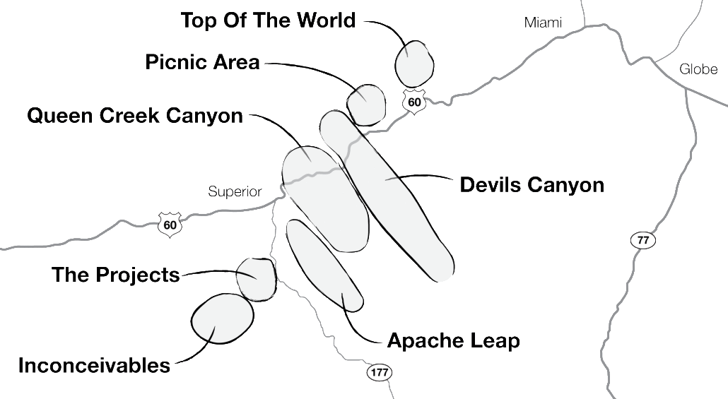
Queen Creek canyon is an outdoor recreation area located four miles east of Superior, Az. The landscape is absolutely gorgeous with towering spires of rock and endless fields of boulders. The Queen Creek area also includes the Oak Flat campground, Apache Leap, and Devils Canyon all located mostly in the Tonto National Forest. For a rock climber, the Queen Creek area has a lifetime of routes and boulders to be climbed. Conveniently located less than one hour from Phoenix or Tucson and with year round climbing weather, This climbing area has proven to be very popular with local and visiting climbers. There are close to 1000 routes and 2000 boulder problems developed, and climbers still have not scratched the surface on how extensive the area is.
Since the first route was developed in the 1970s, the Queen Creek area has become a Mecca for rock climbers. The 1989 through 2004 Phoenix Bouldering Contests and Phoenix Boulder Blasts were held in the Oak Flat campground, drawing in hundreds of top athletes from around the world. Eventually the Queen Creek area became a destination crag for all types of rock climbers and recreationalists.

Apache Leap
The Apache Leap is hard to miss especially when you are approaching Superior from the West. This huge 400′ wall of rock overlooks the town of Superior just south of Queen Creek Canyon. The name is derived from a legendary battle that Apaches fought for the area: they chose to jump from the top of the cliff rather than be captured by their enemies. The Leap holds many of the tallest climbing routes in the Queen Creek Area. Most climbers access the Apache Leap by parking at the Mine Area and hiking to it. For the Gerinimo Area, park on the road to Lower Devils Canyon, then hike west to the Apache Leap. If you are climbing just in the Mine Area, don’t forget to check out the Lost Horizon area just south of the three Telephone poles on the Leap side.
Location: End of Magma Mine road at the entrance of the mine. Look for small parking area just before “No Entry” fence. The Mine Area is all of the rock just west of the small parking area. The leap is the cliffs edge just beyond the Mine Area. Apache Leap includes: Lectra Area, Lost Horizon, Rim Gym, Staging Area, Punk Rock, Headstone, Citadel, The Draw, Musicland Wall, Geronimo Area, Skyscraper Area, and The Fin.
Number of routes: 80
Number of boulder problems: 16
Guides: Queen Creek Guidebook MK, Queen Creek Guidebook MK/SH, Central Arizona Climbers Guide JW/BG/LT, Apache Leap guide MK, Rock N’ Road TT, Rockclimbing.com, Dr.Topo.
Queen Creek Canyon

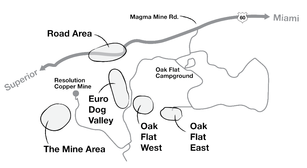
Queen Creek canyon is an outdoor recreation area located four miles east of Superior, Az. The landscape is absolutely gorgeous with towering spires of rock and endless fields of boulders. The Queen Creek Canyon Climbing area also includes the Road Area, Oak Flat East and West, Eruo Dog Valley and The Mine area, all located mostly in the Tonto National Forest. For a rock climber, the Queen Creek area has a lifetime of routes and boulders to be climbed. Conveniently located less than one hour from Phoenix or Tucson and with year round climbing weather, This climbing area has proven to be very popular with local and visiting climbers. There are close to 1000 routes and 2000 boulder problems developed, and climbers still have not scratched the surface on how extensive the area is.
Road Area
The Road area is hard to miss since you can drive through it on Highway 60. The Road Area is beautiful with its hundreds of pinnacles that form Queen Creek canyon. Highway 60 winds through Queen Creek canyon, through a short tunnel, over an exposed bridge and down into the town of Superior. Definitely a scenic adventure! This area has always been considered impassable otherwise, since even to this day it leaves the highway engineers scratching their heads on where a new road is going to go. Along the road are many pullout parking areas that serve as photo opportunities for the spectators, and parking areas for the climbers to access the cliffs. Most of the climbers climb on the Little England Wall, Atlantis Area, and the Pond. The Pond seems to attract the most climbers out of all of the other areas in the Road Area.
Location: Rock formations along Highway 60 through Queen Creek canyon. Specifically from the tunnel area to the corral area (mile 230). The Road Area includes: Atlantis, Little England Wall, the Old Tunnel, Queen Sceptre, El Paso Wall, The Pond, Sunday School Wall, Shooting Gallery, Winnebago Wall, Diamond Buttress, Wounded Knee Wall, and South End.
Number of routes: 245
Number of boulder problems: 86
Guides: Queen Creek Guidebook MK, Queen Creek Guidebook MK/SH, Phoenix Rock JW, Central Arizona Climbers Guide JW/BG/LT, Road Area mini-guide MK, Rock Climbing Arizona SG, Weekend Rock LA, Arizona Mountaineer, Rock N’ Road TT, Rockclimbing.com, Dr.Topo., Rock & Ice Magazine #45, Climbing Magazine, Arizona Highways.
Oak Flat East
Beautiful canyon and plateau filled with different size boulders. The landings are mostly flat and many of the problems have top rope anchors already in place. Oak Flat East is the home of many of the Phoenix Bouldering Contests where many of the rock climbing superstars bouldered for years. Awesome boulder problems in a cool shady
environment. Local favorite areas are the Maze and Piranha Wall.
Location: From Oak Flat Campground, travel south and west up 4WD dirt road for 1/4 mile, follow road west to dead end. The canyon to the south and east is Oak Flat East. For 2WD vehicles travel east from Magma Mine Road up FR469 road toward Upper Devils Canyon. This is the road before the campground. Follow for 1/4 mile and turn right (south) and follow dirt road on flat plateau west until it intersects with top of 4WD road. Oak Flat East includes: Piranha Wall, Hillside Stranglers, Main Wall, Wash Boulders, Entrance Boulders, Road Area, Lonely Boulder, Hidden World North, Hidden World South, The Maze, Ninja Wall, Vector Arena, Bamba Wall, Laser Wall, Eddie-Ortega Boulder, and Binghamland.
Number of routes: 2
Number of boulder problems: 450
Guides: Queen Creek Guidebook MK, Queen Creek Guidebook MK/SH, Phoenix Bouldering Contest maps TW, Climbing Magazine, Rock & Ice Magazine, Fitness Magazine, Sweat Magazine, VBouldering Magazine, Fox News
Channel 3, Arizona Mountaineer, AZ Climber Newsletter, ESPN, Outdoor Life Network, Superior Sun, Copper Country News, Rock N’ Road TT, Rockclimbing.com, Dr.Topo, azbouldering.com, AZ Republic, AZ Gazette.
Oak Flat West
Fun canyon and plateau filled with hundreds of different size boulders. The landings are mostly flat and many of the problems have top rope anchors already in place. Oak Flat West is the home of many of the Phoenix Bouldering Contests where many of the rock climbing superstars bouldered for years. Awesome boulder problems in a cool shady environment. Local favorite areas are Atlantis #2, Davey Jones locker and Guppy Wall.
Location: From Oak Flat Campground, travel south and west up 4WD dirt road for 1/4 mile, follow road west to dead end. The canyon to the west is Oak Flat West. For 2WD vehicles travel east from Magma Mine Road up FR469 road toward Upper Devils Canyon. This is the road before the campground. Follow for 1/4 mile and turn right (south) and follow dirt road west until it intersects with top of 4WD road. Also can reach Oak Flat West from Euro Dog Valley side off of the Magma Mine Road across from the Euro Dog Campground Boulder pullout. Oak Flat West includes: The Sirens, Spider Wall, The Nautilus, Atlantis #1, Atlantis #2, Piranha Flats West, Piranha Flats East, Sentinel, Bermuda Triangle, Sharks Tooth, Guppy Wall, Shark Wall, Davey Jones Locker, Waterfall Canyon, Tetons, and Warm-up Boulders.
Number of routes: 0
Number of boulder problems: 450
Guides: Queen Creek Guidebook MK, Queen Creek Guidebook MK/SH, Phoenix Bouldering Contest maps TW, Climbing Magazine, Rock & Ice Magazine, Fitness Magazine, Sweat Magazine, VBouldering Magazine, Fox News channel 3, Arizona Mountaineer, AZ Climber Newsletter, ESPN, Outdoor Life Network, Superior Sun, Copper Country News, Rock N’ Road TT, Rockclimbing.com, Dr. topo, azbouldering.com, AZ Republic, AZ Gazette.
Euro Dog Valley
Fun secluded canyon with many balanced formations. One of the locations of the past Phoenix Bouldering Contests so you know it has awesome bouldering. The moderate routes are all on the Titanic Wall and the insanely difficult routes are all on the Hook Wall. The Hook Wall now has the most 5.12 and 5.13 routes in the Queen Creek Area. Euro Dog Valley is very comfortable with tall shade trees and many cool formations of rock to explore.
Location: West side of Magma Mine road at cattle guard grate just before hairpin turn and road to Lower Devils Canyon. Euro Dog Valley includes: Campground Boulder, Crocodile Rock, Barracuda Boulder, Peter Pan Playground, Tree House Rock, Tinkerbell Wall, Mrs. Beisleys Wall, Lost Boys Wall, Hook Wall, Tick and Flea Boulder, Mermaid Lagoon, The Titanic, Scatterbrain Boulder, Cattle-guard Boulders, Yakov Wall, Discovery Wall, Y2K, Oasis Wall, Hill Top Boulders, Oven Wall, Purgatory Wall, Sun Deck Boulders, North Euro Dog Boulders, and Mayniac Wall.
Number of routes: 73
Number of boulder problems: 400
Guides: Queen Creek Guidebook MK, Queen Creek Guidebook MK/SH, Euro-Dog Valley mini-guide MK, Phoenix Bouldering Contest maps TW, AZ Climber Newsletter, Arizona Mountaineer, Climbing Magazine, Rock & Ice Magazine, Fitness Magazine, Sweat Magazine, ESPN, Outdoor Life Network, Rock N’ Road TT, Superior Sun, Copper Country News, Rockclimbing.com, Dr.Topo, azbouldering.com, AZ Republic, AZ Gazette.
The Mine
Tons of short 3 to 5 bolt sport routes, yeah! The Mine Area is fun since it is like the landscape you would see on the moon. Small thimble domes of rock that all melt into each other as if Dr. Seuss designed the area. The Mine Area is great for the whole family, grandma, dogs, three month old, everybody since it is so easy to hike around. Fun boulder hopping area, and wedging through the corridors and up the chimneys provides great fun too. The Copper Mine is presently doing studies and work in the Mine Area so please don’t interfere with the mining equipment.
Location: End of Magma Mine road at the entrance of the mine. Look for small parking area just before “No Entry” fence. The Mine Area is all of the rock just west of the small parking area. The Mine Area includes: Magma Dump, Entrance Boulder, Upper Looner Land, Lower Looner Land, Garland Area, Magma Gardens, Pillars of Pain, Simpson’s Hall, Acme Acres, The Grodens, The Main Event Wall, The Crucible Area, Shoe Tips, Tardis Rock, and Coopers Town.
Number of routes: 155
Number of boulder problems: 126
Guides: Queen Creek Guidebook MK, Queen Creek Guidebook MK/SH, Mine Area mini-guide MK, Weekend Rock LA, Arizona Mountaineer, Rock N’ Road TT, Rockclimbing.com, Dr.Topo.
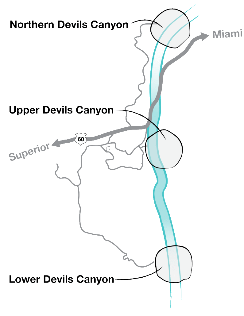
Devils Canyon

Northern Devils Canyon
Beautiful hidden canyon. Just the hike to the canyon is great for a family of all ages. Beautiful scenery and an easy trail to follow. The creek usually has water in it which flows for half of the year. Routes are long and steep and are littered with pocket hand holds. Some of the best moderate routes in the Queen Creek Canyon area are located in Northern Devils Canyon.
Location: From Highway 60 near mile 231, travel north on the dirt road for 2 miles to a power sub station up on the hill. Drive around the substation and up the small hill to a pullout on the right just before the cow pond. Park, hike into the creek and follow it 1/2 mile east to Northern Devils Canyon. Northern Devils Canyon includes: Boy Scout Wall, Solstice Tower, Shamen Wall, Mr. Butterworths, Smith Rock Wall, Benadryl Wall, Diamond Dog Buttress, Stormwatch Wall, Amphitheater, Pocket Plaza, South End, Transformer Area, Creek Walls, Troll Hut, Karatower, Lottaloofah Pinnacle, Ice Scream Scoop, and Hand of Fate.
Number of routes: 135
Number of boulder problems: 120
Guides: Northern Devils Canyon mini-guide MK, Rock N’ Road TT.
Upper Devils Canyon
Beautiful scenic canyon. Most of the routes are all on the west side of the canyon so sun in the morning and shade in the afternoon. The Throne/Pancake House area is one of the best areas to learn to climb at. Well protected moderates and a lot to climb. The Pancake House is a shaded clubhouse of climbing fun. The Beach Area sports the hardest routes in Upper Devils Canyon. Don’t forget to check out the classic climbs at the Lost Wall.
Location: From the Magma Mine Road, travel east up gravelly half paved road (first road on left before Oak Flat Campground) and travel road to power lines. Turn right (south) on powerline road then immediate left (east) and park by the power line tower. Short hike east leads you to the trail to the Throne/Pancake House Area. For the other climbing areas at Upper Devils Canyon, park further up or down the power line road for access to the climbing routes.
Upper Devils Canyon includes: Hee-Haw Pinnacle, Lost Wall, The Wanderer, Universe Wall, The Throne, Pancake House, Devils Den, Berlin Wall, The Beach, Looney Tunes Area, and Spring Chicken Area.
Number of routes: 105
Number of boulder problems: 35
Guides: Queen Creek Guidebook MK, Queen Creek Guidebook MK/SH, Upper Devils Canyon mini-guide MK, Arizona Mountaineer, Rock N’ Road TT, Rockclimbing.com, Dr. Topo, Climbing Magazine.
Lower Devils Canyon
Huge towering formations. Routes that go on forever, in a good way! Lower Devils Canyon is the most beautiful area in the Queen Creek Area. Hiking down Hackberry Creek while the water is flowing is an outstanding site! The hillsides are green with life and the rock shoots up toward the sky for hundreds of feet. The rock is very flat with many bomber edges and slits that you can get natural gear placements into. The area involves a 4WD vehicle to get to, or walk the extra mile from the parking area.
Location: Just after the Euro Dog Valley cattle guard the Magma Mine road will make a large hairpin turn. At this hairpin turn there is a dirt road that travels directly south. This is the road to Lower Devils Canyon. Follow the road south and then east for two miles to a hill. The hill can be conquered with a 2WD vehicle but the last hairpin turn on the down side is what usually stops most vehicles. Most 2WD vehicles park at the bottom of the hill and hike the last mile to Lower Devils Canyon from there. Lower Devils Canyon includes: Zog Area, Bachelor Party, Z-Bop Area, Unknown Wall, Road Area, Glitter Box, Totem Pole, Hackberry Creek, Wonder Wall, and Centerpiece Area.
Number of routes: 75
Number of boulder problems: 42
Guides: Queen Creek Canyon Guidebook MK, Queen Creek Guidebook MK/SH, Lower Devils mini-guide MK, Arizona Mountaineer, Rock N’ Road TT, Rockclimbing.com
Other Areas In Queen Creek Include:
• Picnic Area
• Top of the World
• The Projects
• Inconceivables
